Nigeria Regional Info (App Version)
Nigeria is not normally the first destination in West Africa that one thinks of when it comes to tourism or travel, and having a reputation of being one of the world’s most chaotic places hasn't helped either. Yet for the adventurous traveller, Nigeria promises to be a challenging, exciting, memorable and educational experience, offering the opportunity to experience West Africa and to see this raw and vibrant country with all its hidden wonders.
Nigeria is located in south-western coastal Africa, and shares its borders with Niger, Benin, Chad, and Cameroon in Central Africa to the south-east. Nigeria’s total land mass covers 923,768km and is five times larger than Ghana, 13 times as large as Sierra Leone and occupies a seventh of West Africa.
Nigeria is West Africa's most visited country, and Africa’s ninth most visited as a whole. It is also Africa's most populous, with more than 140 million people and more than 370 diverse ethnic groups. It is home to Lagos, a city with an estimated population that exceeds 10 million, and therefore is on the United Nations’ list of mega-cities.
The name Nigeria is formed from the words 'Niger' and 'area', and was first proposed by Lady Flora Shaw , who later married Lord Lugard the 1st Governor-General of the Colony and Protectorate of Nigeria. At the time she was based at Lokoja the then capital of the goverment of Nigeria by the River Niger in the 19th century.
The country is home to about 200 different and distinct tribes, the largest of which are the Hausa and Fulani (in the north), the Yoruba (in the south-west), and the Igbo (in the east).
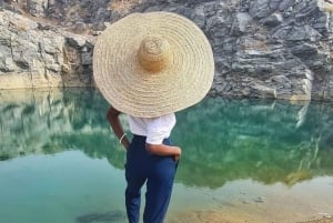
Nigeria boasts great stretches of unbroken sandy beaches bordering the Atlantic to its south, mangrove swamps in its Niger Delta, mahogany forests to the west, savanna grasslands in the middle belt, and arid bush lands to its north. The main rivers are West Africa's greatest river - the Niger - and the Benue River, which converge and flow into the Niger Delta. This is one of the world's largest river deltas and home to the Central African mangroves.
532612
English, Pidgeon (Broken English), Yoruba, Igbo, and Hausa
Nigeria is divided into 36 colourful states, and six regions. Each state enjoys a high degree of autonomy and can set industrial policies and independently seek to attract investment. This is usually done within the broader national policy and must comply with federal rules (with regard to import duties, for example). The 6 regions are:
North Central
North Central Nigeria consists of the seven states situated geograhically in the middle belt region of the country, spanning from the west, around the confluence of the River Niger and the River Benue. The region itself is rich in natural land features, and boasts some of Nigeria's most exciting scenery. The region is also home to many historical and colonial relics. States in this region are, Benue, Kogi, Kwara, Nasarawa, Niger, Plateau State, and Abuja (Federal Capital Territory).
North Eastern
The north-eastern part of Nigeria comprises of six states, with this region mostly known for the production of crops and livestock which contribute greatly to the economy of the country. The region is densely populated as compared to the southern region of the country. The major tribes are Hausa and Fulani and they are largely muslim. States in this region are, Adamawa, Bauchi, Borno, Gombe State, Taraba State, and Yobe.
North Western
The north west region of Nigeria offers a wide range of Islamic beauty and culture, from the Seat of Caliphate in Sokoto to the Land of Equity to the Free Trade Zone in Jigawa. It was formed from parts of the old Northern Region. This area of the country covers six states; Sokoto, Zamfara, Kebbi, Kaduna, Katsina, Jigawa. It majorly consists of Hausas and Fulanis and the religion in the region is Islam. The weather is usually dry and the temperature drops at night. States in this region are, Jigawa, Kaduna, Katsina, Kebbi, Sokoto State, and Zamfara.
South Eastern
South-eastern Nigeria was one of the initial 12 states created during the Nigerian Civil War, which later broke into the present Akwa Ibom State and Cross River State. South-east became the name of one of the six geo-political zones in the country in the 1990s consisting of Abia State, Anambra State, Ebonyi State, Enugu State and Imo State. The local language in this region is Igbo. Before the British colonial government, South-eastern Nigeria was home to many ethnic groups such as the Igbo, Ijaw, Ibibo, and Efik. These groups mostly had democratic systems of government and several kingdoms, such as Nir Akwa Akpa (Calabar), Aro Confederacy and Opobo which were huge influences in the region. States in this region are, Abia, Anambra, Ebonyi, Enugu, and Imo.
South South
The South South region of Nigeria comprises of six states and is strategically located at the point where the Y tail of the river Niger joins the Atlantic Ocean through the Gulf of Guinea. Though a relatively small stretch of land, the south of the country provides the economic mainstay of the economy: oil. In addition to oil and gas, the region equally contributes other key resources, with potential huge investment opportunities in tourism and agriculture. States in this region are, Akwa Ibom, Bayelsa, Cross River, Delta, Edo, and Rivers.
South Western
The south west region of Nigeria offers a wide range of sights and experiences; from the beaches in Lagos to the natural springs in Osun state and from the historic city of Ibadan to the mountain caves of Ogun state. It is majorly a Yoruba speaking area, although there are different dialects even within the same state. The weather conditions vary between the two distinct seasons in Nigeria; the rainy season (March - November) and the dry season (November - February). The dry season is also the bringer of the Harmattan dust; cold dry winds from the northern deserts blow into the southern regions around this time. States in this region are, Ekiti, Lagos, Ogun, Ondo, Osun, and Oyo.